

The Pegasus F200 is an advanced industrial-grade high-precision UAV system developed by Pegasus Robotics since the F1000 series. Built on the F200 high-precision drone platform, it offers users multiple data acquisition options. Its modular payload design includes visible light, near-infrared, thermal infrared, and video data capture capabilities, along with large-scale mapping, 3D modeling, and other data processing functionalities. With the UAV Manager Professional Edition software, users can benefit from GPS solutions, control point measurement, aerial triangulation, and high-precision image stitching, providing comprehensive large-scale aerial survey solutions. The F200 system continues Pegasus Robotics' commitment to high industrialization, reliability, and automation, focusing on high reliability, single-operator functionality, and repeatable high-precision operations.
System Parameters
Material: EPO + Carbon Fiber Composite
Wingspan: 1.9m
Length: 1.07m
Standard Takeoff Weight: 3.7kg (Aerial Survey System)
Maximum Takeoff Weight: 3.8kg (Tilt System)
Cruising Speed: 60km/h
Maximum Battery Life: 1.5 hours
Highest Hand Throw Altitude: 4500m
Ceiling: 6000m (Altitude)
Flight True Height: 150-1500m
Control Radius: 10km
Takeoff and Landing Methods: Hand throw/auto downhill/parachute
Payload: Multi-module Interchangeable (Aerial Module/Tilt Module/Video Module/Near Infrared Module/Thermal Infrared Module)
Signal Tracking: GPS: L1/L2; BD: B1, B2; GLONASS: L1, L2
Sampling Frequency: 20Hz
Positioning Accuracy: 5cm
Solution Mode: PPK
System Features
1. Dual-Frequency Differential GPS Positioning System
Provides centimeter-level POS data for uncontrolled or sparse control point mapping.
2. Multi-source Data Acquisition Capabilities
Supports full-frame cameras/tilt cameras/near infrared/thermal infrared/video modules.
3. One-stop Large-Scale Mapping Solution
Covers the entire process from route design, control point measurement, aerial triangulation to high-precision and fast image stitching.
4. Active Service Based on Pegasus Cloud
Timely push of critical information, real-time synchronization, and multi-terminal sharing.
5. Fast Mission Response, No Remote Control Needed
Modular design, tool-free assembly/disassembly, fully automatic take-off and landing mission mode, supports single-user operation.
Main Components
1. UAV Special Frequency Digital Radio Station
Independently developed by Pegasus Robotics, certified by the Radio Regulatory Commission, operates in the 840.5MHz-845MHz dedicated frequency band, with frequency-hopping design for strong interference resistance.
2. Smart Battery Module
The Pegasus dedicated smart battery module allows one-handed installation and replacement, supports battery usage monitoring, and provides a one-click view of power levels to protect the battery from overcharging and over-discharging risks.

3. One-Time Parachute
The patented one-time parachute from Pegasus is stack-free, maintenance-free, cost-effective, and adaptable to various harsh terrains, ensuring safe parachute deployment in emergencies.
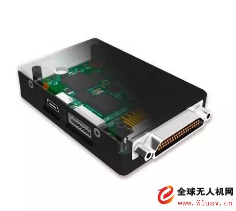
4. Autopilot
â–º High Precision Dynamic Redundancy Attitude Detection System
â–º Advanced Total Energy Algorithm
â–º Automatic Task Mode
â–º High-Reliability Task Scheduling and Process Communication Based on Real-Time Operating System
â–º Support for Full System (GPS, Beidou, GLONASS) Dual-Frequency GPS Signal Reception, GPS+INS Combined Navigation Algorithm
â–º PPK Solution Provides Centimeter-Level POS Data
Tilt Module
The F200 tilt module features a unique dual-camera design that combines intelligent route planning with high-quality side-texture acquisition and high-efficiency operations. The F200 tilt system is 10 times more efficient than traditional multi-rotor tilt drones, primarily targeting wide-ranging engineering projects.
1. Module Parameters
Camera Model: SONY QX1*2
Sensor Size: 23.2*15.4
Effective Pixels: 20.1 million (5456*3632)*2
Lens Parameters: 20mm Fixed Focus (Custom Lens)
Lens Angle: Left 38° Left Tilt; Right 25° Backward Tilt
Acquisition Resolution: Better Than 3.5cm
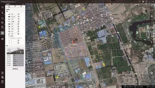
2. Route Design
The Drone Butler's "Smart Route" supports automatic tilt route generation: planning or importing blocks can automatically fill in target resolution and overlap requirements, generating routes automatically with auto-division and other functions.
Route Design
The F200 tilt route is designed by default for round-trip routes. With its unique dual-camera angle design, the side surface textures of the coverage area can be obtained in a single sub-route. For tasks with lower texture requirements, non-round-trip designs can also be used, doubling data acquisition capacity.

Camera Footprint
3. Custom Lens
The camera lens of the F200 tilt module uses Sony's custom 20mm fixed-focus lens. The lens is set to default infinity focus mode, reducing the difficulty of camera setup and improving focus stability and image acquisition quality.
4. Data Preprocessing
The UAV Butler’s "Intelligent Diagram" has the EXIF write function, which can directly write the high-precision POS data of the F200 to the photo EXIF. After writing, it can be directly imported into software like Context Capture for data processing, effectively reducing data collation and pre-processing work.
5. Work Efficiency
Acquisition Resolution Heading Overlap Side Overlap Degree Round Trip Design / Shelf Non-Round Trip Design / Shelf Times / Day 3.5cm 80% 65% 1km² 2km²
≥4
5cm 80% 65% 1.5km² 3km² 10cm 80% 65% 3km² 6km²
Applications
1. Three-Dimensional Modeling Case of the Potala Palace
On November 2, 2016, the Pegasus intelligent aerial survey system F200 successfully captured the tilt data of the Potala Palace. This flight marked the first time in China that a drone was used for aerial photography at the Potala Palace. The data collected were used for the three-dimensional reconstruction of the Potala Palace.
The target area of the Potala Palace covers 0.75km², with a regional height difference of 50m. Using the "Smart Route", a round-trip design was implemented with a ground resolution of 4cm, an overlap of 80%, and a side overlap of 65%. The total route covered 45km and the operation lasted 45 minutes.

Potala Palace Route Design
On the day of the flight, the F200 was originally scheduled to take off from the Potala Palace Square at an altitude of nearly 3,500m. However, after on-site reconnaissance, it was determined that the Potala Palace had a complex environment with many tourists. To ensure flight safety, the take-off and landing plan was adjusted to take off and land on the roof of the Potala Palace tower instead of the square.

Potala Palace Wall Takeoff
Landing at the Potala Palace Square
After approximately 45 minutes of aerial photography, the F200 landed safely. During the flight, a total of 1,904 original images were captured. Using the modeling software Context Capture, the following modeling results were obtained:

Original Image

3D Modeling Results

3D Modeling Results

3D Modeling Results
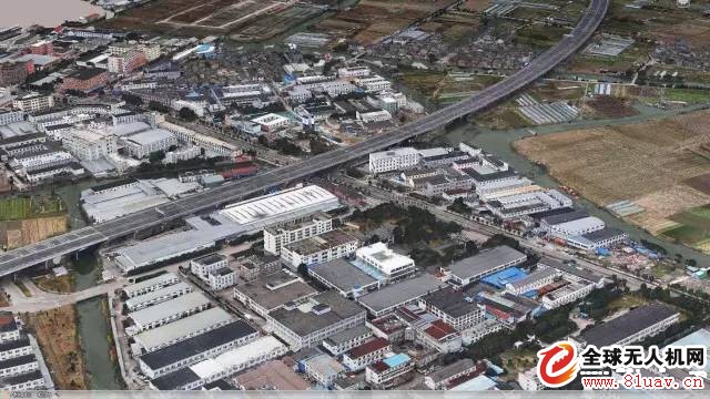
2. Three-Dimensional Modeling Case of Zhangzhou City
On October 20th, 2016, the F200 equipped with a tilt module completed the acquisition of 1 square kilometer of tilt data for the Zhangzhou Municipal Service Center. The F200 flew for 30 minutes and obtained more than 2,000 valid original photos. The data results are as follows:

Overall 3D Modeling Results

Local 3D Modeling Results

Local 3D Modeling Results
Local 3D Modeling Results
3. Three-Dimensional Modeling Case of Kashgar City
On November 27th, 2016, the F200 equipped with a tilt module completed the acquisition of 6 square kilometers of tilt data in Kashgar City. The project aimed to meet rapid modeling needs. The route design used non-round-trip design with a design resolution of 7cm and a total of 2 flights. The data results are as follows:

3D Modeling Results
3D Modeling Results

3D Modeling Results

3D Modeling Results

3D Modeling Results
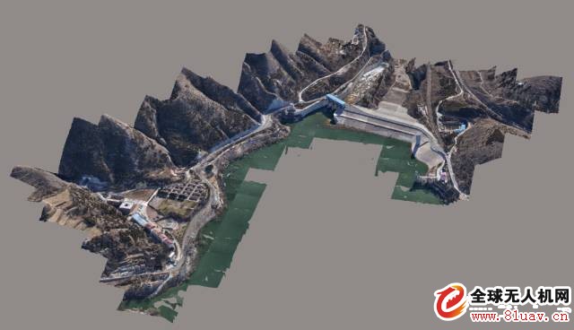
4. Three-Dimensional Modeling Case of Guanting Reservoir
On December 1st, 2016, the F200 equipped with a tilt module completed the three-dimensional data acquisition of the Guanting Reservoir dam area. The flight was conducted once, covering an area of 1 square kilometer, with a flight time of 50 minutes. The original image was obtained at 2,076. The modeling results are as follows:
3D Modeling Results

3D Modeling Results
5. Three-Dimensional Modeling Case of Ningbo Dongqian Lake
In November 2016, the F200 equipped with a tilt module completed the 10 square kilometer tilt data acquisition of Ningbo Dongqian Lake. The design resolution was 5cm. The route was designed with round-trip routes and a total of 7 flights. The route design and modeling results are as follows:

Route Plan

Survey Results Summary

Partial Outcome

Detailed Result
Detailed Result
6. Ningbo City Rail Transit Real-World 3D Project
In April 2017, F200 completed the 3D project of Ningbo Rail Transit Real Estate with a total area of about 90 square kilometers.

Survey Route Plan
The target survey area is strip-shaped, with a preset altitude of 200-230 meters and a ground resolution of ≯5cm. For high-rise buildings, the altitude is 300-400 meters and the ground resolution is 8cm. The project uses two-machine collaborative work, and the effective construction period is 15 days.
Strip 3D Results
Partial Outcome

Partial Outcome
Poker Mat,Poker Table Mat,Round Poker Mat,Poker Pad
Cixi Mingsheng Rubber & Plastic Co.,Ltd. , https://www.popmat.com