Vehicle scheduling system without blind area based on GPS / Beidou satellite technology
The modern vehicle scheduling system is a high-tech project integrating global satellite positioning technology (GPS), geographic information technology (GIS) and modern communication technology. It transmits the dynamic position (longitude and latitude), time, and status of the moving target to the control center in real time through a wireless communication link, and then displays the moving track of the moving target on an electronic map with geographic information query function. And monitor and query the user's interested parameters such as the target's position, speed, direction of movement and vehicle status. At present, this type of system mainly uses the GPS / GSM method to complete the positioning communication requirements. However, the simple GPS / GSM vehicle scheduling system cannot fully meet the needs of daily life, such as in remote western regions, deep mountain old forests, etc. A very sharp problem is that when there is no GSM signal or the GSM signal is covered, the vehicle scheduling system is completely ineffective. In addition, due to strategic considerations, the United States may turn off GPS satellite positioning signals during certain extraordinary times (such as war). If our system is completely dependent on GPS, it will inevitably cause great losses. Due to the above problems, we designed and developed a system design based on GPS / Beidou satellites to solve these problems.
2 Introduction to the "Beidou" system At the end of 2000, China established the satellite positioning and navigation system "Beidou-1" independently developed by China. The system is a regional navigation system that provides satellite navigation information around the clock and around the clock, and will mainly provide positioning and navigation services for China's transportation, transportation, and marine operations.
The same as the positioning system, China's "Beidou" positioning system is different from the United States' Global Positioning System (GPS). GPS is passive (broadcast) and can be positioned when the signal is received. The number of users is not limited, but communication cannot be achieved Function; and the "Beidou" positioning system is active (response type), and realizes the positioning function by establishing contact with the central station, and has the communication function. The "Beidou" positioning system has the ability to combine communication and navigation. Two synchronous real-point satellites can be used for two-way information exchange. The Beidou navigation positioning satellite system supports 200 positioning or short message services on the uplink and downlink respectively, which is much higher than the concurrent processing capabilities of Inmarsat-C / OmniTrack and other systems ; Coverage of all areas and sea areas of mainland China, compared with the telecommunications cellular network in the true sense of no blind area coverage. The main system components of Beidou satellite navigation and positioning system are:
(A) Beidou satellite: composed of 2 geosynchronous satellites (1 spare satellite in orbit);
(B) Beidou ground control center: It consists of five parts: signal transceiving, information processing, dispatching, clock, test subsystem and supporting equipment;
(C) User machine: a terminal for satellite navigation positioning users. The service scope is divided into two types: ordinary type and command type. Each command-type user machine can control 100 ordinary user machines; the ordinary user machine can be divided into four types according to the mode of transportation: portable, vehicle-mounted, shipborne, and airborne.
3 Overall system architecture The system consists of vehicle-mounted terminals, communication links, central servers and monitoring terminals. Its overall structure is shown in Figure 1. The vehicle-mounted terminal completes vehicle positioning, trajectory storage and information transmission, the wireless communication link completes information exchange, the central server completes connection and data storage with the vehicle-mounted terminal and the monitoring terminal, and the monitoring terminal completes vehicle monitoring.
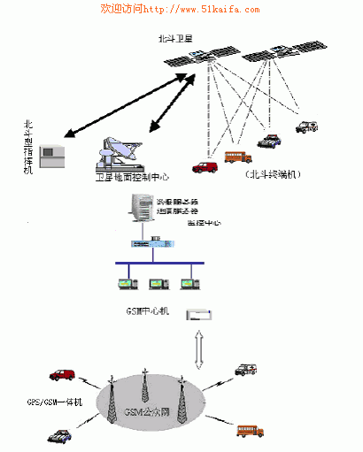
Figure 1 overall system diagram
3.1 System working principle
When the dispatch information appears, the vehicle GPS receiver receives the positioning data of GPS satellites, calculates its own geographical latitude and longitude coordinates, and then sends the location, status and alarm information to the control center through the GSM module of the vehicle station and stores it in the database; When the GSM signal cannot be captured, the Beidou satellite positioning system is activated. This system has dual functions of positioning and communication, and sends information such as the position and status of the vehicle to the control center through the satellite system.
3.2 Introduction of on-board unit The on-board unit is divided into GPS part and "Beidou" part.
The GPS vehicle equipment uses GSM / GPS integrated machine, equipped with a standard serial port, which can output NEMA-0183 standard GPS positioning data. In addition, the vehicle equipment can carry out voice calls and data communications. Normally, the vehicle station uses the GSM short message method and the control center contact.
The "Beidou" part uses vehicle-mounted user terminals, and its technical indicators are:
Beam width: pitch direction: 25 ° ~ 90 °; horizontal direction 0 ° ~ 360 °;
Frequency: L / S band transmission / reception, strong rain attenuation resistance, less than 0.3dB attenuation of rain and fog
Number of receiving channels: ≥2;
First capture time: ≤4 seconds;
Lost lock recapture time: ≤1 second;
Received signal error rate: ≤10-5;
Transmitted EIRP value: ≥13 dBW;
Transmit frequency offset: ≤2 × 10⁻⁷;
Transmit signal power stability:
± 0.5dB (the longest transmitted signal period at a time);
± 1 Db (24 hours, working environment conditions);
Carrier suppression of transmitted signal: ≥30 dB;
Power consumption: DC 10 ~ 32V ripple ≤1%, with power supply logic control function;
Standby sleep power consumption: 300mW;
Average power consumption: ≤6W;
Maximum transmit power: ≤20W;
When the GSM signal can be received, the information of the vehicle-mounted unit (location and other requested service information) transmits GPS positioning information and sending messages through the GSM network; when the GSM signal is not received, the positioning communication function of the "Beidou" system is used to install The Beidou user machine on the moving target sends a positioning application to the positioning main station through satellites. The positioning main station calculates the longitude and latitude of the target location based on the two satellite signals received, and transmits it back to the user machine through the satellite. Position information, at the same time, the commander to which the user machine belongs also gets the position information. The commander directly transmits the location information to the positioning data server and GIS server connected to it, and displays the vehicle location on the electronic map. The personnel of the monitoring center implement effective scheduling and monitoring of the vehicle based on intuitive graphic information, and complete the data communication from the mobile vehicle to the user command and control center through the above process.
3.3 Introduction of control center This system adopts the working mode of C / S structure combined control of main control center + reception desk. The main control center is composed of a database subsystem, a communication subsystem, and a call acceptance subsystem; the reception desk includes a communication subsystem, a GIS subsystem, and the main control center and each reception desk form a computer network through dedicated lines to exchange data and share information with each other to realize groups High requirements for dispatching, network alarm, and absolute guarantee of safety.
The structure of the control center is shown in Figure 2.
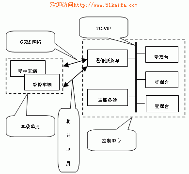
Figure 2 Block diagram of the control center
3.4 Main functions of the system Vehicle tracking and monitoring:
Track and monitor the position (including longitude and latitude) of the moving vehicle, and visually display the running position of the vehicle on the electronic map of the monitoring area. The positioning interval can be set independently.
Command and Control:
The monitoring center can implement voice or digital command and dispatch of the vehicle through the call handle of the on-board equipment.
Alarm acceptance:
When the vehicle alarms, the monitoring center will receive the prompt of sound and light alarm, at the same time, it will automatically track the screen of the alarm vehicle, display the distance indicator centered on the alarm vehicle, and display various parameters of the alarm vehicle according to the vehicle archives, such as the number , Model, license plate, color, owner, etc.
Vehicle control:
Relevant technical measures are taken. After the vehicle is stolen, the monitoring center can make the vehicle inoperable by remotely shutting down the vehicle, and can also let the vehicle send out a sound and light for help.
Vehicle management:
Combined with vehicle position information and status information, the working conditions of vehicles and drivers can be effectively recorded and counted.
Data report output:
Daily and monthly alarm table record output, alarm location map, user usage report, login and logout table output. The monitoring center can check the daily log-in or log-out information of the vehicle, and can also check the vehicle file, and can print out the daily monitoring report.
Vehicle track playback:
The monitoring center can play back the past driving routes of the controlled vehicles at any time.
Network management:
Network management of main control center and reception desk.
Information deployment:
The control center has all users' information, and geographic information and auxiliary information of all service areas. It can schedule the system resources of the entire network, and allocate the number of users who realize various tracking at the same time between each user monitoring center.
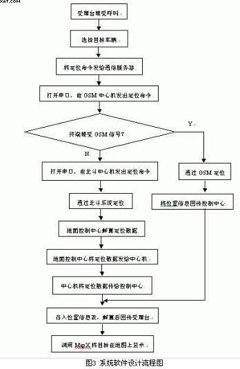
4 System software design The main modules of the software system include target positioning scheduling, data transmission, track playback, and basic information management of moving targets. The system uses a C / S structure and uses Windows Sockets, large databases, TCP / IP networks, MapX and other technologies to realize the integration of the "Beidou" system and GPS, expanding the scope of application. The software flow chart is shown in Figure 3.
In the design of system software, we have used some mainstream technologies to make our system an open system, with full consideration in compatibility and scalability. In the realization of data transmission on the network, we mainly use Windows Sockets technology, and use the very popular TCP / IP protocol to transfer data. In the design of GIS system, MapInfo was used to make electronic maps and MapX secondary development tools were called to complete various operations of electronic maps. In accessing the database, we use the ADO data interface under the Microsoft ODBC standard to access the database.
5 Database management design Under the premise of considering the performance and price ratio of the system, after the demonstration, the MS SQLSERVER2000 database is adopted. System database includes GIS database and system database. According to the user's login information to operate different permissions, set multiple levels such as ordinary operator level, commander level, system management level, system maintenance level, etc., for different levels of users can have different use permissions.
The GIS database stores geographic information, including map information and its spatial relationships; the system database includes positioning information tables, vehicle information tables, communication information tables, vehicle status information tables, and abnormal information tables.
6 Concluding remarks This system establishes a mobile target scheduling system with "Beidou" as the positioning communication means and a complete function, which can effectively locate, track, communicate, command, dispatch and manage mobile targets in real time, and realize the "Beidou" system and GPS The integration of the mobile target scheduling system has been expanded; the positioning communication function of the Beidou satellite system has been fully applied, which integrates the scheduling navigation and communication of the mobile target scheduling system, improves the overall integration of the system, and facilitates the dispatch center's Dispatch management.
The positioning part of today's mobile target scheduling system is based on GPS of the United States or GLONASS of Russia. There is basically no mobile target scheduling system based on the Beidou satellite navigation system developed by China. By fully drawing on previous experience, the vehicle scheduling system established in this paper takes into account the particularity of the "Beidou" system and the functions required for moving target vehicle scheduling. The system has been successfully used in the 120 emergency system, which has gained user support and recognition and laid the foundation for the application of the "Beidou" system in other fields.
Plated Plastic Housing Coffee Grinder
Coffee Mill Grinder,Coffee Grinder Machine,Automatic Coffee Grinder,Plated Plastic Housing Coffee Grinder
FOSHAN FORTUNE ELECTRICAL APPLIANCE CO.,LTD , https://www.coffelady.com